推荐下载

-
2020-05-12 浏览:740

-
2020-05-06 浏览:521

-
2020-05-08 浏览:510

-
2020-04-04 浏览:505

-
2020-05-12 浏览:502
微信小程序位置API
发布时间:2020-11-18
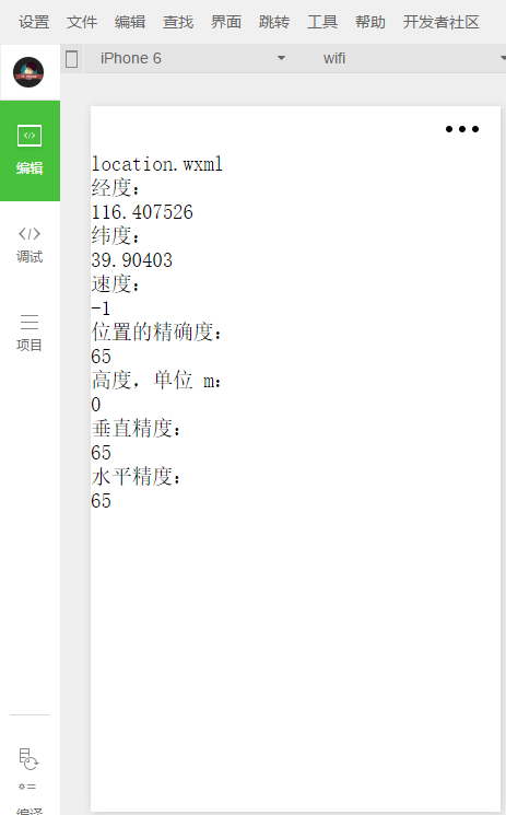
wx.getLocation(OBJECT)
获取当前的地理位置、速度。当用户离开小程序后,此接口无法调用;当用户点击“显示在聊天顶部”时,此接口可继续调用。
[javascript] view plain copy
var that=this;
wx.getLocation({
type: 'wgs84',
success: function (res) {
var latitude = res.latitude
var longitude = res.longitude
var speed = res.speed
var accuracy = res.accuracy
var altitude = res.altitude
var verticalAccuracy = res.verticalAccuracy
var horizontalAccuracy = res.horizontalAccuracy
that.setData({
longitude: longitude,
latitude: latitude,
speed: speed,
accuracy: accuracy,
altitude: altitude,
verticalAccuracy: verticalAccuracy,
horizontalAccuracy: horizontalAccuracy
})
}
})
wx.chooseLocation(OBJECT) 打开地图选择位置

2、查看位置
wx.openLocation(OBJECT) 使用微信内置地图查看位置
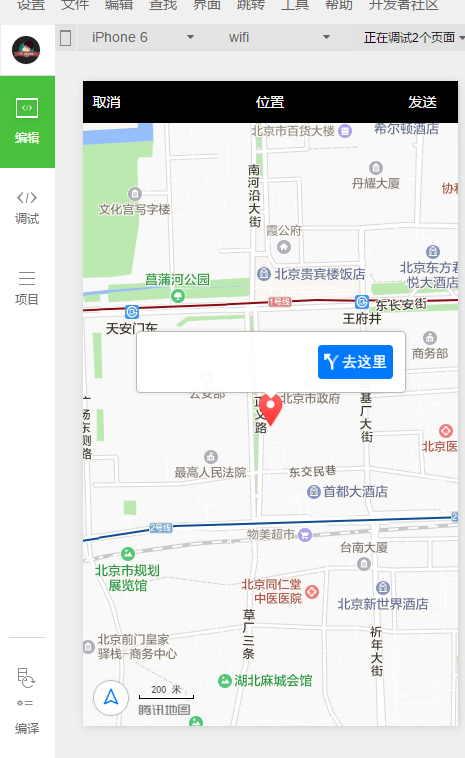
wx.getLocation({
type: 'gcj02', //返回可以用于wx.openLocation的经纬度
success: function(res) {
var latitude = res.latitude
var longitude = res.longitude
wx.openLocation({
latitude: latitude,
longitude: longitude,
scale: 28
})
}
})
3、地图组件控制
wx.createMapContext(mapId) 创建并返回 map 上下文 mapContext 对象 mapContext mapContext 通过 mapId 跟一个 组件绑定,通过它可以操作对应的 组件。 mapContext 对象的方法列表
方法 参数 说明 最低版本 getCenterLocation OBJECT 获取当前地图中心的经纬度,返回的是 gcj02 坐标系,可以用于 wx.openLocation moveToLocation 无 将地图中心移动到当前定位点,需要配合map组件的show-location使用 translateMarker OBJECT 平移marker,带动画 1.2.0 includePoints OBJECT 缩放视野展示所有经纬度 1.2.0 getCenterLocation 的 OBJECT 参数列表
参数 类型 必填 说明 success Function 否 接口调用成功的回调函数 ,res = { longitude: "经度", latitude: "纬度"} fail Function 否 接口调用失败的回调函数 complete Function 否 接口调用结束的回调函数(调用成功、失败都会执行) translateMarker 的 OBJECT 参数列表
参数 类型 必填 说明 markerId Number 是 指定marker destination Object 是 指定marker移动到的目标点 autoRotate Boolean 是 移动过程中是否自动旋转marker duration Number 否 动画持续时长,默认值1000ms,平移与旋转分别计算 animationEnd Function 否 动画结束回调函数 includePoints 的 OBJECT 参数列表
参数 类型 必填 说明 points Array 是 要显示在可视区域内的坐标点列表,[{latitude, longitude}] padding Array 否 坐标点形成的矩形边缘到地图边缘的距离,单位像素。格式为[上,右,下,左],安卓上只能识别数组第一项,上下左右的padding一致。开发者工具暂不支持padding参数。
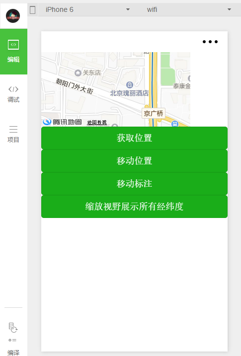
<!-- map.wxml -->
<map id="myMap" show-location />
<button type="primary" bindtap="getCenterLocation">获取位置</button>
<button type="primary" bindtap="moveToLocation">移动位置</button>
<button type="primary" bindtap="translateMarker">移动标注</button>
<button type="primary" bindtap="includePoints">缩放视野展示所有经纬度</button>
// map.js
Page({
onReady: function (e) {
// 使用 wx.createMapContext 获取 map 上下文
this.mapCtx = wx.createMapContext('myMap')
},
getCenterLocation: function () {
this.mapCtx.getCenterLocation({
success: function(res){
console.log(res.longitude)
console.log(res.latitude)
}
})
},
moveToLocation: function () {
this.mapCtx.moveToLocation()
},
translateMarker: function() {
this.mapCtx.translateMarker({
markerId: 0,
autoRotate: true,
duration: 1000,
destination: {
latitude:23.10229,
longitude:113.3345211,
},
animationEnd() {
console.log('animation end')
}
})
},
includePoints: function() {
this.mapCtx.includePoints({
padding: [10],
points: [{
latitude:23.10229,
longitude:113.3345211,
}, {
latitude:23.00229,
longitude:113.3345211,
}]
})
- 上一篇:WeChat 文章列表页面(一)
- 下一篇:【小白专用】微信小程序支付,微信支付
